A combination of geophysical techniques can be used by GBG to map the extent and intensity of contamination plumes. Electrical methods and Ground Pentrating Radar(GPR) can be used based on the site conditions and expected contaminants. Generally, contaminated areas will produce a different geophysical response to the surrounding area. This allows for effective remediation strategies to be considered. We can locate and map water tables, groundwater pollution and underground storage tanks.
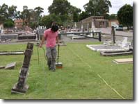
GBG have completed numerous jobs locating unmarked graves and archaeology sites using non-invasive methods. There are several motives for locating buried remains. Cemeteries with incomplete burial maps can use our services to update these maps and confidently release empty plots to clients. Developers may need to ensure that proposed works will not disturb existing burials in areas where anecdotal evidence for graves is available. Heritage groups and archaeologist have used GBG to help map historical burials or plan for excavations. The police force also has a use for unmarked grave location to locate crucial evidence over broad areas.
GBG conducts tree root mapping services with the use of Ground Penetrating Radar(GPR). From this developers can arrange construction work around a tree to minimise any future impacts to both the tree and the structural integrity. Aborists can also use a tree root map to assist in determining the health of the tree and the extent of any impacts from past/present/future construction. Surveys are performed over a clear and flat site but tree roots cannot be seen beneath reinforced concrete.
Tunnel investigations can quickly provide an assessment of the tunnel condition and construction. Ground Penetrating Radar(GPR) data is collected along lines spanning the length of the tunnel and at points around the circumference. Once collected, data can be used to map voids, liner thickness and condition, overbreak depth and fill material. GBG is experienced in surveying both rail and road tunnels nationwide. This method has proven to be more efficient than traditional coring and spot checking.
GBG use Ground penetrating Radar(GPR) to investigate the ballast depth and condition within the rail corridor, this technique can rapidly collect kilometres of data and can be performed in conjunction with planned stoppages. The surveys find areas of fouling, moisture and abnormal layer thicknesses. GBG Australia uses the same technology to undertake GPR investigations on road pavements to determine thicknesses of construction materials down to an inch thick. We also utilise other geotechnical methods including Depth Core Penetration (DCP) testing and MASW to provide thorough dataset, depending on the scope of the investigation.
GBG Australia undertake Greenfield and Brownfield site investigations for geotechnical and environmental purposes, using various geophysical methods as well as standard sampling, CPT or DCP tests. Information can be provided over a wide area locating buried waste or obstructions to excavation or compaction. We can also provide continuous soil compaction profiles using Multi channel Analysis of Surface Waves (MASW). When coupled with CPT and seismic refraction testing, depth to bedrock and ripability figures can be established accurately.
Unknown risks on any development site are a major component of cost overruns and variations and as such having a greater understanding of what can be expected under the surface of a Greenfield or Brownfield site will keep those costs in control. Typical physical investigations such as trial pits of drill holes may only give point source information and not the full picture. By incorporating geophysical investigation methods into a site assessment a more holistic view of the site and its underlying conditions becomes apparent.
GBG Australia has considerable experience in a number of seismic techniques such as Seismic Reflection and Refraction, Marine Seismic applications and a relatively new technique: Multichannel Analysis of Surface Waves (MASW).
GBG Australia is proficient in all steps of the seismic process from data collection to interpretation. With a variety of seismic sources (including a weight drop and two air guns) GBG are equipped to perform a survey at whatever scale you require. We possess a suite of the latest seismic processing software that allows for quicker, more accurate and more informative results than ever before. Our new topographic imaging software allows any survey to generate precise geotechnical information of engineering value.
GBG Australia is one of only a few companies in Australia with in-house equipment for Marine Refraction Surveys to provide bedrock depths and strengths for geotechnical assessment. We have 2 Bolt Air gun sources and a number of bottom towed or static arrays which can be set up and combined to provide profile depth of 1 50m depth. All the equipment is portable and can be set up on a boat from 6m to 20m length depending on the extent of the job and depth of the water. All data is tied together with DGPS referencing. We also undertake other shallow marine geophysics such as single channel subsurface reflection, marine magnetometer, side scan sonar and dual frequency Bathymetry. Through our link with McMullen and Nolan surveys in WA we have highly skilled survey staff for location and navigation referencing.
Shallow marine investigations can be undertaken for dredging, marina or port development, pipe line or cable routes, river crossings or just to locate missing objects such as large anchors or containers that have fallen off vessels in navigation routes or dredge channels.
Using EM methods GBG has conducted surveys over hundreds of hectares to map salinity. Equipment and coverage can be easily scaled to suit the size of the site and resolution as required. Data acquisition is relatively fast and tied to DGPS referencing so it can be correlated with bore holes and monitoring wells on the site to provide a complete picture of saline conditions.
GBG can apply environmental geophysical techniques to assist in the location of underground water resources. We have expertise in all main techniques used, especially electrical and electromagnetic techniques and will tailor the survey to the individual parameters through research of the surrounding geology and surface conditions.
We use geophysical methods to map out contaminant plumes in three dimensions over areas of any size. Groundwater pollution and hydrocarbon leakage can be mapped out along with any underground storage tanks which may be the source of the contaminants. Results can be provided on a base map making it easy to correlate with sample locations or wells. These surveys are more accurate and detailed than merely sampling via wells and can be used to create a more efficient sampling regime. By performing more than one survey, changes in the shape and extent of the contamination can be clearly seen, giving a four dimensional model.
GBG is adept at employing various geophysical methods to delineate the extents of known resources against the background geology. Among the types of resources we can delineate are coal seams, ore bodies (VHMS, porphyry etc.) and alluvial deposits of precious stones and their associated geology. It is possible to determine the extents, volume, geometry and depth of a deposit given the right geological contrasts exist to be detected with one of our many geophysical techniques.
GBG Australia has a number of techniques for determining the volume of overburden over a mineral deposit. We are equipped to use a number of useful techniques such as Ground Penetrating Radar, electrical resistivity, total field magnetic, gravity and seismic refraction surveys. These techniques complement each other and the exact combination of techniques would depend on the local geology. A survey would delineate the overburden and the ore body in a number of continuous profiles, giving a number of 2D cross sections of the overburden thicknesses. A geophysical survey allows for continuous mapping of the subsurface, reducing the need for drilling and providing better economic models for the life of the mine.